
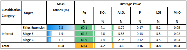
Alien Metals (UFO ) has announced its maiden Inferred Resource in excess of 10Mt @60.4% Fe for its Hancock Iron Ore Project.
The independent Mineral Resource Statement has an effective date of 16 September 2021 and covers three targets within the tenement boundary: the Sirius Extension Target and Ridge C and Ridge E that form part of the Western Ridges prospect.
Whilst the quantity and grade of the reported inferred resource are, by definition, uncertain in nature, it is highly likely that further exploration drilling will result in upgrading them to an Indicated or Measured Mineral Resource category with the reasonable prospect for eventual economic extraction.
The Reverse Circulation drilling was used to obtain 1m samples via a 4-way splitter, from which 3kg was pulverized to produce a 30g charge for fire assay.
Table 1 shows the resulting Mineral Resource Statement for the Hancock Project with all material reported within the optimised pit shells and within the tenement boundary.
Table 1: Mineral Resource Statement, Hancock Iron Ore Project, Alien Metals, September 2021
Bill Brodie Good, CEO & Technical Director of Alien Metals, commented: “We are really pleased to have delineated in excess of 10Mt of DSO iron ore with our initial MRE at Hancock. With only a quarter of the Western ridges targets tested to date, we believe there to be considerable scope to grow the DSO resource over the next 6 months.
Having a sizeable maiden resource is encouraging; having DSO material with low impurities is even more pleasing and we are pushing ahead with scoping study work with Mining Plus and continued planning for the Phase 3 drilling programme.”
View from Vox
The initial Inferred JORC compliant resource stands at 10.4Mt @ 60.4% Fe, including 7.8Mt @ 60.1% at the Sirius Extension target, 1.5Mt @ 61.2% on the Ridge E target and 1.1Mt @ 61.9% Fe at the Ridge C target.
These results are significantly ahead of what the market was expecting with the low levels of deleterious elements indicating that Hancock could produce high-quality Direct Shipping Ore (DSO) product.
Clearly, Ridges E and C are only partially tested to date, and the Company feel they have considerable potential to define further DSO grade material, which would provide further resource upgrades and positive re-rating on the shares.
Mineral Resource Statement
Figure 1 shows the location of the Hancock Project, tenement number E47/3954, which is approximately 10 km north of Newman in the prolific iron ore producing Pilbara region of Western Australia.
Figure 1: Location of Hancock Iron Ore Project, Western Australia
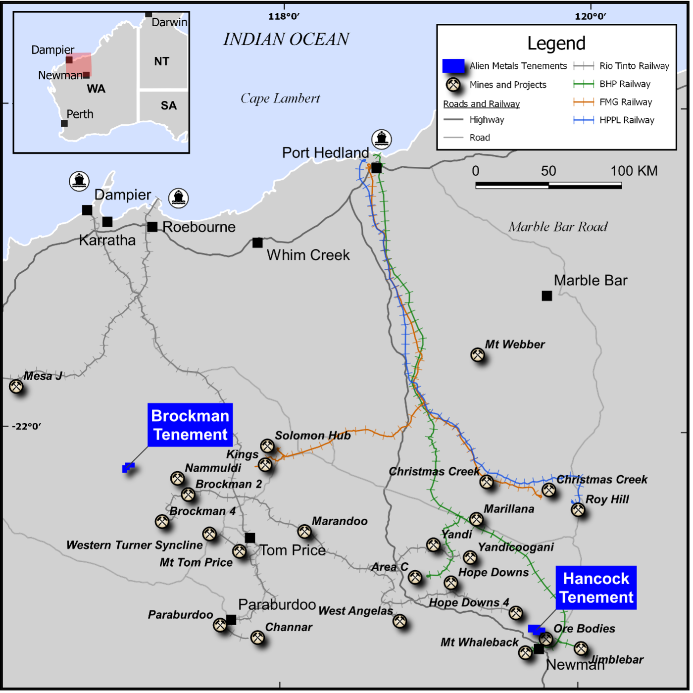
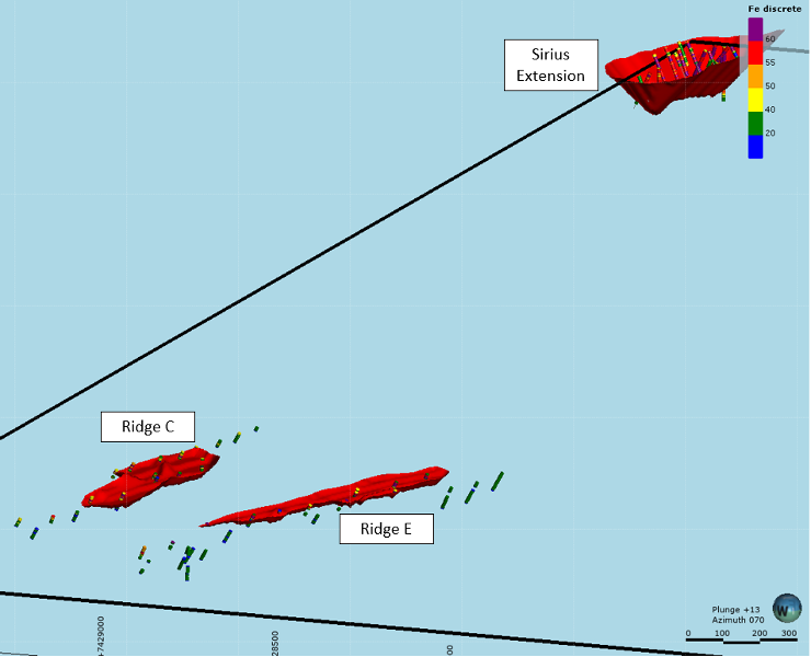
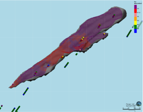
Figure 2 and Figure 3 illustrate the drill collars / traces and the final optimised pit shell used for reporting the final Mineral Resource Statement.
The topographic surface shown in Figure 2 highlights the prominent ridges within the tenement.
Figure 2: Tenement boundary and target location. Drill collars (green) and the optimised pits (red)
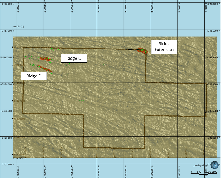
Figure 3: Tenement boundary and target location (Drill traces coloured by Fe% and the optimised pits shown in red)
Geology and Geological Interpretation
The tenement area consists of a series of low east/west running rocky ridge lines separated by shallow valleys.
The area has been structurally deformed with the presence of numerous fold hinges, some isoclinal, but all trending east/west with a shallow (<34°) plunge.
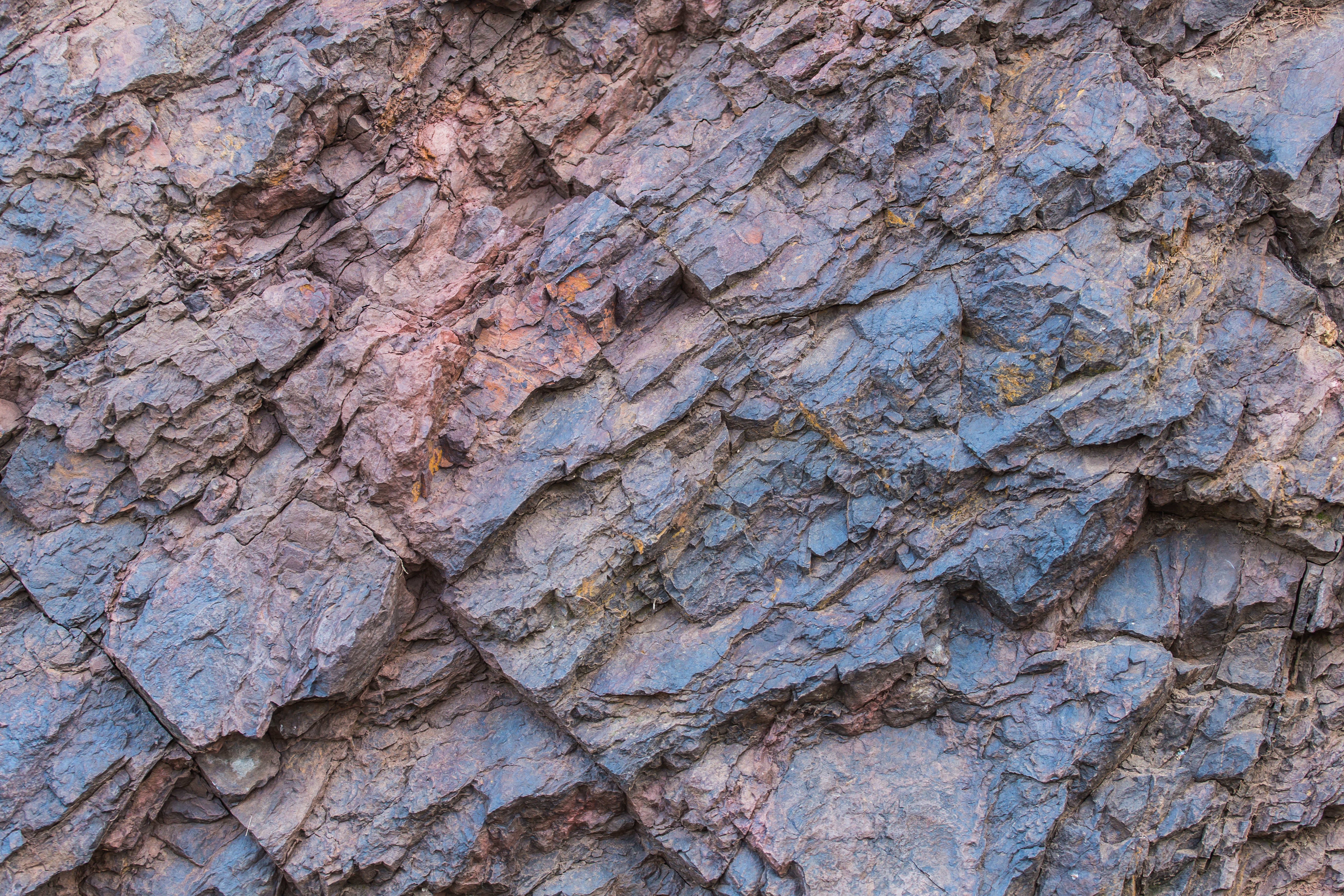
Most of the ridge lines consist of Banded Iron which is part of the Weeli Woolli Formation.
The Weeli Wolli Formation is described as a thick succession of jaspilite, shale, and dolerite overlying the Brockman Iron Formation. The iron formations stand out as ridges on which there is some exposure, but the intervening shale and dolerite are rarely exposed.
The logging and assay data has been used to define the mineralised Banded Iron Formation (“BIF”) units along with a weathered cap located at surface where possible. At the Sirius Extension target, a steeply dipping BIF unit has been modelled along with a weathered cap domain. The BIF domain has been further subdivided into low / high Silica domains following a review of geochemical data. Figure 4 shows the BIF/ Cap domains with Figure 5 showing the division of the BIF domain into high/ low Silica domains.
Figure 4: Sirius Extension BIF (Brown) and Weathered Cap (Blue)
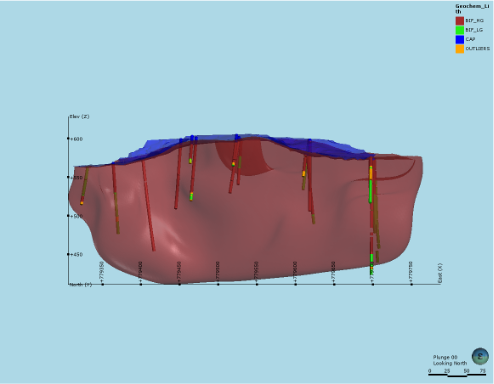
Figure 5: Sirius Extension High Silica domain (purple) and Low Silica domain (red)
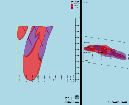
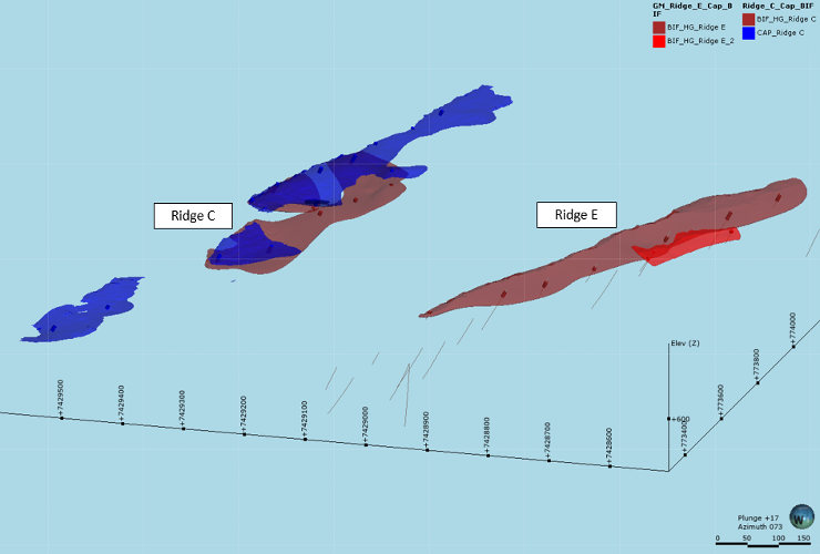
At the Western Ridge Prospect, Ridge C has been modelled to contain a single BIF domain and a weathered cap domain and Ridge E has been modelled to contain two separate BIF domains. No weathered cap has been modelled at Ridge E. At both Ridge C and Ridge E, limited data restricts the interpretation with the overall dip of the mineralised units being reliant on mapping data with a dip of between 15° and 20° being used to guide the modelling process.
Figure 6: Ridge C and Ridge E BIF and Cap domains
Mineral Resource Estimation
The Mineral Resource Estimate was completed in Leapfrog Software with additional statistical studies completed in Supervisor. Samples were composited into 2 m lengths prior to geostatistical studies and grade estimation.
The composite files for each target were used in a geostatistical study that enabled Ordinary Kriging (“OK”) to be used as the main interpolation method for the Sirius Extension target. Robust variograms could not be produced at Ridge C and Ridge E due to the limited data and as such, an Inverse Distance Weighting interpolation was carried out for these targets.
The interpolation used an elliptical search following the predominant dip and dip direction of the geological zones with a variable orientation used within the surficial Cap domains where the topographic surface is a contributing factor to the domain and grade distribution.
For each domain where variography was possible, variography was completed on all assay fields being estimated into the block model, these being Fe, SiO2, Al2O3, P, MnO and LOI. Figure 8 shows the Sirius Extension block model with the model and drillhole file coloured by Fe grade.
A density of 3.0 t/m3 was applied to all mineralised BIF material with a density of 2.5 t/m3 applied to the weathered Cap. A density of 2.8 t/m3 was applied to all external host material.
Figure 7: Sirius Extension Block model and drillhole file coloured by Fe %
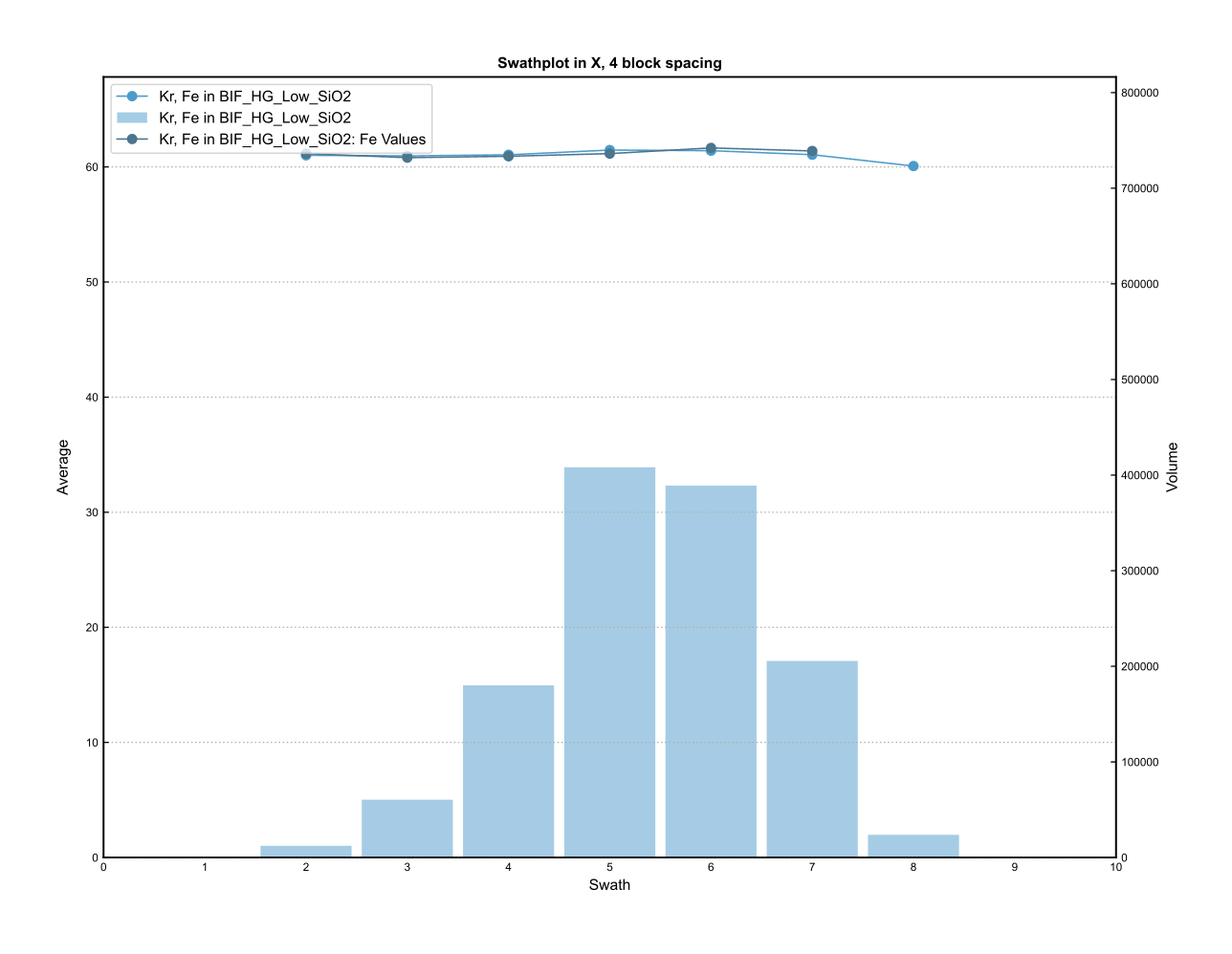
The interpolated block model was validated through visual checks and a comparison of the mean input composite and output model grades. As an example, Figure 9 and Figure 10 show SWATH plots for the Sirius Extension high and low Silica domains. As shown, a strong correlation exists between the input composite and output block model grades in the easting direction shown.
BGS is confident that the interpolated block grades are a reasonable reflection of the available sample data available.
Figure 8: Sirius Extension Fe SWATH plot, high SiO2 domain
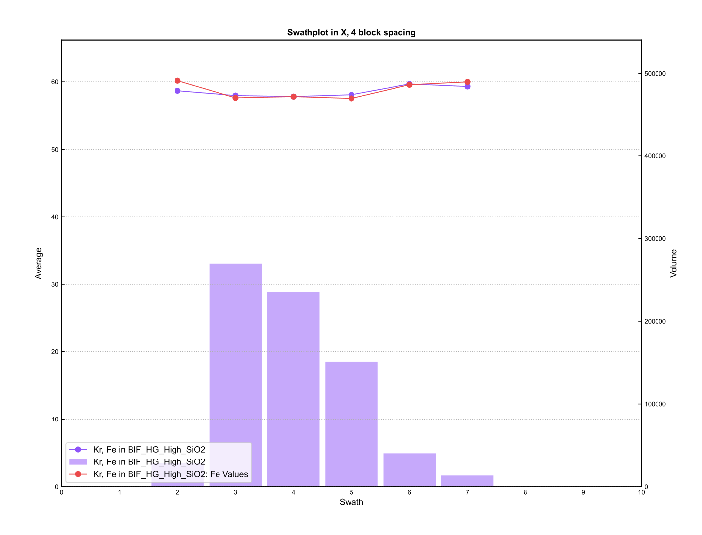
Figure 9: Sirius Extension Fe SWATH plot, low SiO2 domain
Mineral Resource Classification
All deposits have been classified as Inferred Mineral Resources. Primarily, this is due to the lack of density data, the limited data at Ridge C and Ridge E, and the lack of verification diamond drilling to confirm the grade identified through the RC drilling and the drilling challenges observed. That said, continuous packages of mineralised BIF have been identified and BGS is confident that future drilling will increase the classification confidence category assigned.
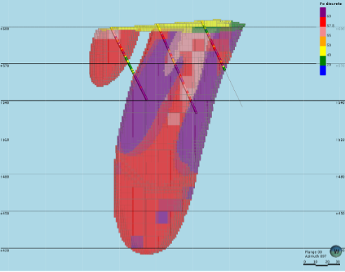
At the Sirius Extension Target, the base of the Inferred Mineral Resources was restricted to the deepest drillhole intersections within the mineralised body, shown in Figure 11. All mineralised BIF material modelled at Ridge C and Ridge E was classified as an Inferred Mineral Resource with no depth restriction, due to the limited down dip extent of the models, shown in Figure 12 and Figure 13.
Figure 10: Sirius Extension classified model and drillhole traces
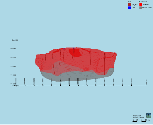
Figure 11: Ridge C classified model and drillhole traces
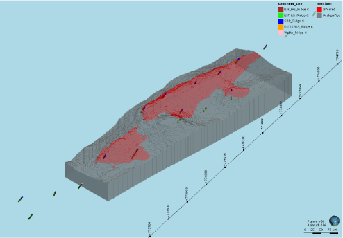
Figure 12: Ridge E classified model and drillhole traces
Open Pit Optimisation
To determine the final Mineral Resource Statement, the model has been subjected to an optimisation exercise to determine the proportion of the material defined that has a reasonable prospect of economic extraction via open pit mining methods. The optimisation was carried out by independent consultants Mining Plus. In addition, Mining Plus undertook an audit of the Mineral Resource Estimate carried out by BGS with no material issues identified.
The optimisation was based on the mineralised BIF material only. The Cap was excluded from the optimisation and is not currently being reported as a mineralised domain. The optimisation used a baseline metal price of USD210/t, a price that has been exceeded over the course of the previous 12 months. BGS comment that Mining Plus also provided optimised pit shells at a baseline price of USD100/t and USD150/t with very little sensitivity shown in the final Mineral Resource Statement.
The interpretation of the word ‘eventual’ in this context relates to a bulk commodity where it is reasonable to envisage ‘eventual economic extraction’ as covering time periods more than 50 years.
No cut-off grade has been applied to the final Mineral Resource Statement due to the general lack of grade sensitivity and the optimisation process undertaken.
At the Sirius Extension Target, approximately 200k tonnes of material has been excluded from the final Mineral Resource Statement as it lies outside of the tenement boundary. The optimisation process did allow the pit crest to extend beyond the tenement boundary, however.
This represents the material considered by BGS to have reasonable prospects for eventual economic extraction potential.
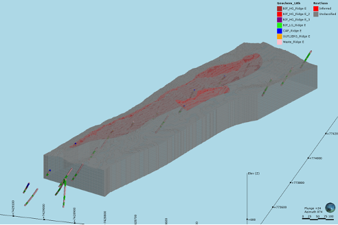
Figure 13 to Figure 15 shows the final Mineral Resource within the USD210/t optimised pit shells.
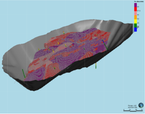
Figure 14: Ridge C Mineral Resource within the optimised pit
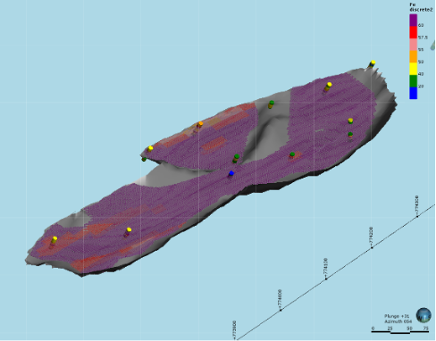
Figure 15: Ridge E Mineral Resource within the optimised pit
Upside Potential and next phase
With the improved understanding of the enrichment horizon and the large extent of untested highly prospective ridges still to be tested and hopefully added into an updated and enlarged future resource.
Alien plans to target the specific horizons in the next drilling programme, with the hope to increase both volume and confidence in these initial mineral resources.
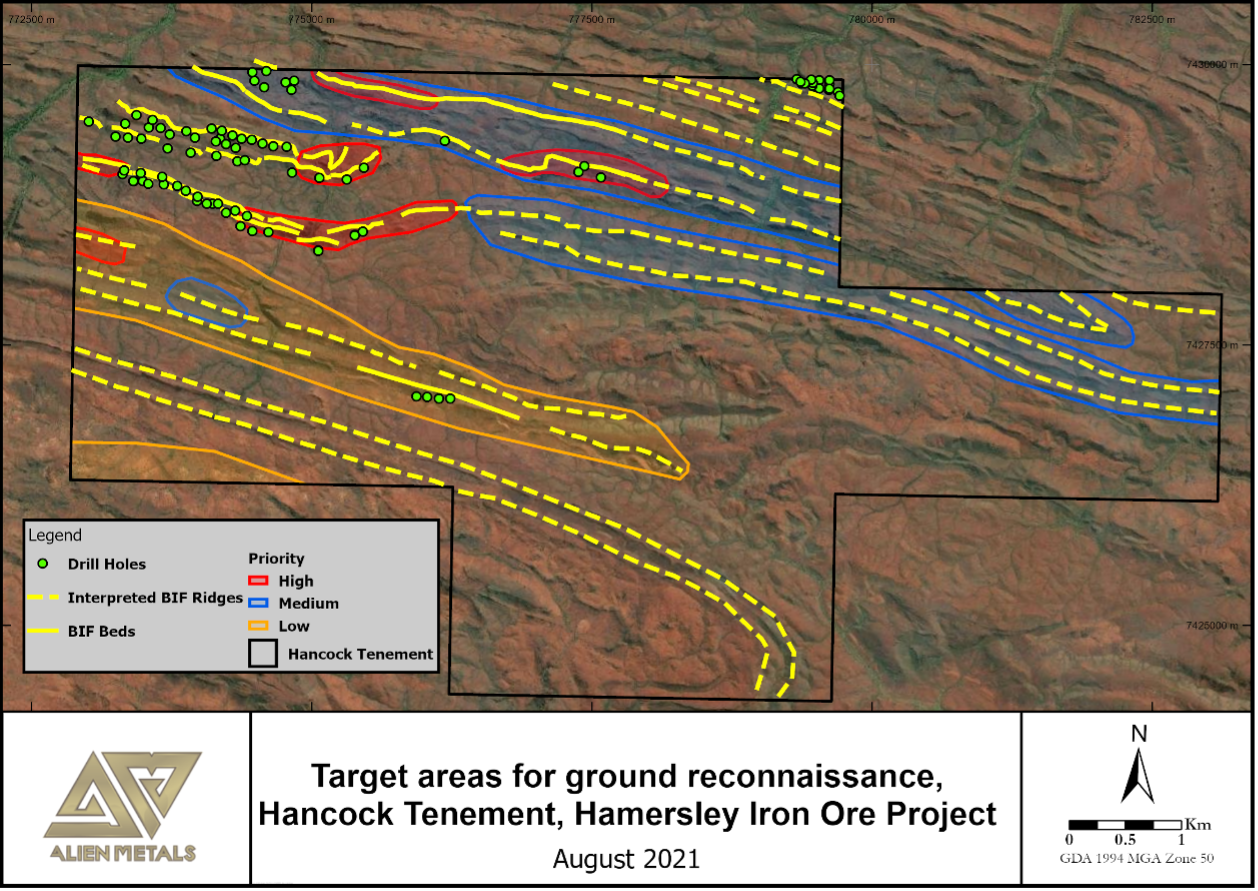
Figure 17 shows the location of the current drilling and the future ridge lines to be drill tested.
Figure 17: Target areas for further ground reconnaissance, Hancock Tenement, Hamersley Iron Ore Project, August 2021